The Often-Missed Section of Badlands National Park That's Wilder and Less Crowded
Did you know that most visitors only stick to the park’s North Unit?

◔ 10 minute read
Badlands National Park's South Unit sits on protected Lakota land, draws almost no visitors, and offers the kind of emptiness that the crowded North Unit can only hint at. Getting there and enjoying it takes a touch of extra effort, but that’s kind of the whole point…
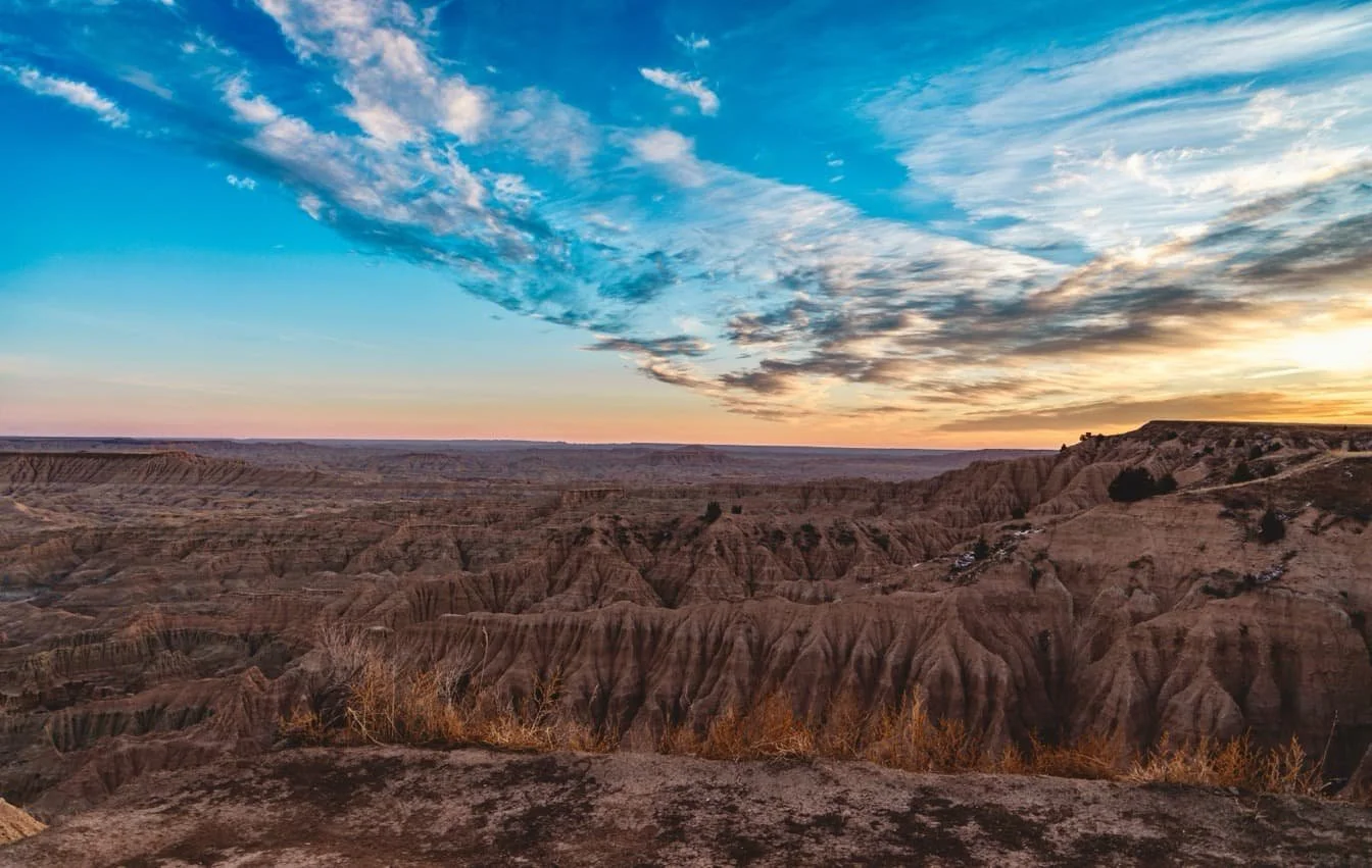
Everyone who stretches a little further to visit Sheep Mountain Table or Red Shirt Overlook remarks on the serious lack of engines, voices, camera shutters. Just the prairie dropping away into eroded formations on three sides, and beyond them, more prairie, all the way to the horizon. On a clear morning, the Black Hills are a dark smudge to the west.
But, surpirisingly, most people who visit Badlands National Park never see this. Close to a million arrive each year, and the vast majority drive the 31-mile Loop Road through the North Unit, stop at a handful of overlooks, photograph a prairie dog town, and carry on towards Mount Rushmore. It's a great drive, but it's a predictable one, and by midsummer, the car parks at Door Trail and Pinnacles Overlook are full before 9am.
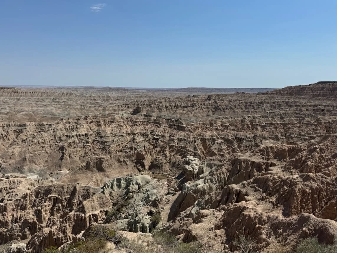
An hour south, the park becomes a completely different place. The South Unit, formally known as the Stronghold District, is 133,300 acres of deep canyons, wind-carved mesas, and rolling mixed-grass prairie, all of it sitting within the Pine Ridge Indian Reservation.
There's no paved scenic road cutting through it, no pricey lodges, no developed campground. The South Unit is raw, unmanaged terrain that isn’t the sanitised, tourist friendly half-experience up north.
A Place Packed with History
The South Unit's story is inseparable from the Oglala Lakota people, and understanding that history isn't optional context.
In 1868, the Second Treaty of Fort Laramie promised the Sioux that the Badlands would remain theirs permanently, a promise broken within a couple of decades By 1889, the treaty had been broken and the land confiscated. In the desperate winter of 1890, as starvation gripped the reservation and the Ghost Dance movement spread among the Lakota
Stronghold Table became the site of what is widely considered the last known Ghost Dance of the 19th century. Hundreds gathered on this remote, flat-topped mesa, accessible through a single narrow gap wide enough for one wagon, to perform the ceremony they believed would restore the buffalo and bring back their dead.
Days later came the massacre at Wounded Knee, roughly 45 miles to the south, where the 7th Cavalry killed more than 250 Lakota men, women, and children. Survivors fled back into the Badlands.
Nothing really changed past that point, either. In 1942, the War Department seized over 340,000 acres of Pine Ridge land, giving residents one week's notice, to establish an aerial bombing range. Families were displaced, livestock lost, sacred sites cratered.
When the land was then declared surplus in the 1960s, it wasn't simply returned. The Oglala Sioux Tribe was told that unless they agreed to let the National Park Service manage it, the land would be disposed of as surplus property and lost to them permanently. The 1976 agreement that created the South Unit was, by most accounts, a choice made under duress.
Today, the NPS and the Oglala Sioux Tribe co-manage the Stronghold District, and a long-running proposal to make it America's first tribal national park, managed and operated by the tribe, awaits congressional legislation.
Plans include a Lakota Heritage and Education Centre. The politics are complex, the timeline uncertain, but the direction of travel is clear: this is Lakota land, and its future will increasingly be shaped by Lakota hands.
Stronghold Table itself remains sacred and is accessible only on foot. You’ll need to seek permission from private landowners before attempting to reach it, and may encounter prayer sticks, fabric tied to branches, or other signs of ongoing ceremonial practice, so be respectful, don’t pose for photos, or worse collect colourful fabric or adornments as souvenirs.
The Other Badlands
The contrast with the North Unit is not just fewer tourists either, it’s a physical difference too. Up north, the Ben Reifel Visitor Center hums with ranger programmes, fossil exhibits, and queues for the toilets.
The South Unit's equivalent is the White River Visitor Center, a converted trailer 20 miles south of the town of Scenic on BIA Route 27, with exhibits on Lakota history and culture and daily ranger talks in season. Yes modest, but more genuine, and it's your last reliable source of drinking water and information before the harsh reality of truly wild land sets in.
Beyond the visitor centre, the South Unit opens up into something closer to what the northern Great Plains looked like before the roads arrived. Table mesas rise hundreds of feet above the surrounding grassland, sharp edges dropping away in vertical walls of pale clay and darker shale.
Red Shirt Table (pictured above), named after a Lakota chief, runs roughly 10 miles along the park's western boundary and is the highest point in Badlands at 3,340 feet. The overlook on Highway 41 is worth arriving early for, when the sun hits the bands of ochre, rust, and lavender.
In late afternoon, the shadows lengthen until the whole formation looks like a relief map rendered in charcoal.
Cool and sometimes still snowy springs brings brief, vivid wildflower blooms across the grassland, whereas autumn turns the cottonwood draws gold. Summer can be sweltering, which is great if you’re into that, an winter can make the South Unit impassable, so you’ll need survival gear and a good understanding of cold weather wilderness practices.
No matter the time of year, night sky, free of any light pollution, is among the darkest in the lower 48 states. Even a quick glance up makes you understand why the Lakota called the Milky Way the Spirit Trail.
Driving the Perimeter
Unlike the North Unit, where the paved Loop Road threads directly through the formations and deposits you at an overlook every half-mile, no road cuts through the South Unit at all. The only real way to experience it by car without the need for a 4×4 and access permissions is the South Unit Drive, a roughly 50-mile perimeter route that traces the unit's edges without ever entering its interior.
Starting from the small town of Scenic, the route heads south on SD Highway 27 to the White River Visitor Center, then west along BIA Highway 2 before turning north on BIA Highway 41, where the Red Shirt Table Overlook offers the drive's finest moment: a vast basin of eroded spires stretching below, with Stronghold Table visible in the distance.
The South Unit drive is a quieter, more contemplative drive than the Loop Road, one where the landscape unfolds slowly at the periphery rather than performing for the camera at every turn. For anyone wanting to go deeper than the road allows, the only vehicle access into the South Unit itself is the dirt track up Sheep Mountain Table.
Sheep Mountain Table: The One Road In
If the South Unit has a signature experience, it's Sheep Mountain Table, the only part of the Stronghold District accessible to visitors without navigating private land permissions.
The dirt road begins 4.5 miles south of Scenic on SD Highway 27 and climbs about five miles to a first overlook, known as the Gunnery Range Overlook for its views across the former WWII bombing range below. That initial stretch is manageable in dry conditions for most vehicles, though rain transforms Badlands clay into something between wet soap and crude cement, and the road closes in all but name. Don’t even try it if you aren’t in a four wheel drive, and even then proceed with caution.
Beyond the overlook, you’ll again be reminded that you’ll need to be in a high-clearance four-wheel-drive vehicle, or things could end badly. But the road onward is completely worth it if you’re ready for some sketchy surfaces, with sublime views on both sides.
At the road's end, you can continue on foot towards Cedar Butte or simply sit on the edge of the table and take in the scale of what's below. The formations here are different from the North Unit's famous wall, deeper canyons and more varied rock strata, and the complete absence of other people makes them feel larger than they are.
Sheep Mountain Table is designated day-use only, and is sacred to the Oglala Lakota, who come here for vision quests and prayer, so wrap up your visit well before sundown.
A Quieter Kind of Wildlife
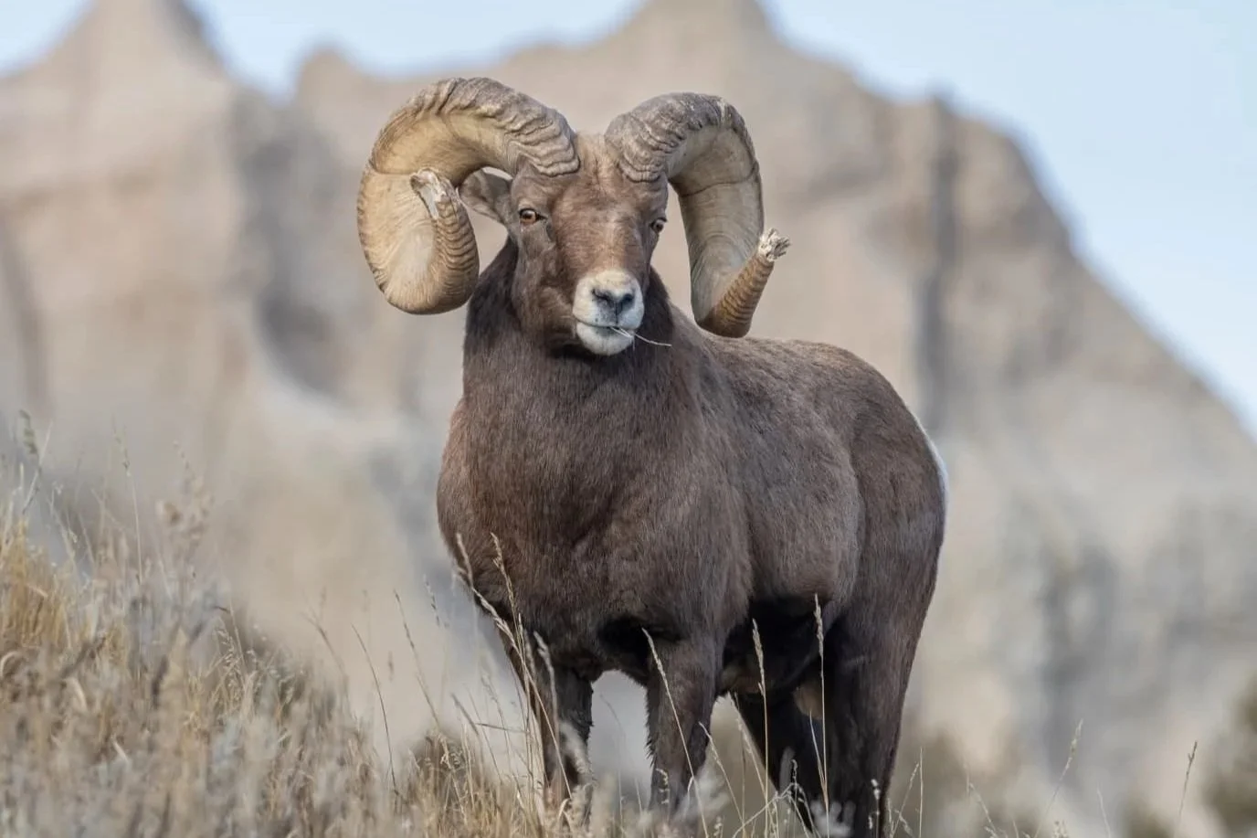
The North Unit's Sage Creek Rim Road is justifiably popular for its bison herd of around 1,200 animals, its bighorn sheep at Pinnacles Overlook, and the busy prairie dog towns at Roberts and Burns Basin.
The South Unit won't match it for guaranteed sightings, but the grasslands here support their own populations of pronghorn, mule deer, and coyotes, and the absence of traffic means the animals behave differently.
The wider Badlands ecosystem also harbours one of the most remarkable conservation stories in North American wildlife. The Conata Basin, straddling the park boundary and the adjacent Buffalo Gap National Grassland, is home to the world's largest wild population of black-footed ferrets, an animal once declared extinct.
The species was rediscovered in 1981 after a ranch dog in Wyoming killed one and its owner, not knowing what it was, brought it to a taxidermist. From a remnant population of just 18 animals captured in 1987, a captive breeding programme led to reintroductions across the Badlands from the mid-1990s.
Today, scientists estimate around 120 to 160 ferrets live in and around Conata Basin, roughly half the world's entire wild population.
They're nocturnal, spending up to 21 hours a day underground in prairie dog burrows, so your chances of seeing one are vanishingly small. But the knowledge that they're out there, having returned from the edge of erasure back to where they belong, gives the grassland a charge it wouldn't otherwise have.
Be Prepared
With a much more raw landscape, you’ll need to think a little harder than simply following the traffic like you would in the North Unit. There's a very real lack of infrastructure here, with no fuel stops, no visitor centres, no public toilets and cell phone service is extremely sketchy, and most of the time non-existant. Stop off in Scenic or Kyle to get way more food and water than you think you’ll need, and to fill your fuel tank to the very top, even for a day trip.
There are no marked hiking trails, and as your phone probaby won’t work, navigation requires topographic maps and genuine backcountry experience. Much of the land beyond Sheep Mountain Table can only be reached by crossing private property, and landowner permission is required, with a list available at the White River Visitor Center. Don’t expect to just turn up, pay a fee and wander.
Dangers aside from the elements exist too. Unexploded ordnance from the WWII-era bombing range still litters parts of the South Unit. A multi-agency task force continues clearing devices, but the NPS advises visitors to contact a ranger if they find anything suspicious, so keep one eye on the ground at all times.
However, none of this is meant to discourage, it’s just to help you arrive prepared, and head back home or to the hotel without the guilt of an emergency ranger call out.
If all of this sounds slightly daunting, but you’re still keen to explore the South Unit, then it’s always worth considering a private tour. Instead of worrying about water supplies, hand over the thinking and navigating to someone who knows the area, and can build a much better picture of the geology, history and wildlife than you’ll be able to.
More to See Nearby
If you’ve grand plans to tour the Black Hills region or head to Mount Rushmore, see Wind Cave National Park, or explore Custer State Park, the South Unit makes a compelling and contrasting addition – and a good alternative if you’re a little more adventurous.
If you stop at the Cuny Table Café, on the road near the Stronghold District, you may be the only visitor that day. It's a useful information point for anyone hoping to access the more remote tables, and a reminder that you're not just in a national park. You're on a reservation, in a living community, on land whose story is still being written.
The South Unit doesn't market itself. It doesn't have to. The emptiness, the weight of the history, the unbroken line of grass meeting sky, these things either pull you or they don't. But if you've driven the Loop Road and felt that there must be something more to the Badlands than a scenic photo opportunity, there is. It's an hour south, and almost nobody goes.